From the suppression of 1307 to the sails of the Santa María, a thread runs through the official story of discovery and it refuses to stay buried
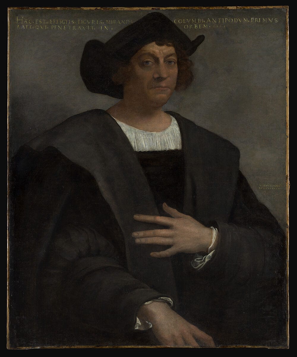
There is a version of history in which Christopher Columbus was a visionary sailing blind into the unknown, driven by faith and a miscalculation about the size of the Earth. It is a satisfying story. It is also, on inspection, a story with several doors that do not quite close.
Columbus was not a man who operated in the dark. He was embedded, through marriage, geography, and professional circumstance, in the most sophisticated maritime intelligence network of the fifteenth century. He spent years in Lisbon and Madeira working as a chartmaker, moving in circles that had access to classified Atlantic knowledge. His father-in-law. Bartolomeu Perestrello was a member of the Order of Christ, the direct institutional successor to the Knights Templar in Portugal — and possessed one of the most significant private collections of Atlantic charts and navigation logs in existence. By some accounts, Columbus received access to that library as part of his marriage arrangement.
When he finally crossed the Atlantic in 1492, he flew the red cross of that same order on his sails.
These are not fringe claims. They are documented biographical facts. What remains open — and what makes this one of the most genuinely interesting questions in the history of exploration — is what, exactly, was in those charts. And where the knowledge in them originally came from.
What Was Columbus Actually Sailing With?
The mainstream account of Columbus acknowledges the Perestrello connection but tends to treat it as incidental. He married well, gained access to some useful navigational material, and this sharpened his thinking about an Atlantic route. End of story.
But this reading rather casually buries the lead.
Bartolomeu Perestrello was not a minor functionary. He had served as a captain under Prince Henry the Navigator and been appointed as the first governor of Porto Santo in the Madeira archipelago,an island at the very edge of the known Atlantic world. He was, in other words, precisely the kind of man who would accumulate the kind of charts that powerful people did not want freely circulated. His collection included logs and maps documenting Atlantic voyages, the details of which were treated by the Portuguese crown as something close to state secrets.
After marrying Felipa Perestrello e Moniz in 1479, Columbus spent extended periods in the Madeira Islands. He worked as a chartmaker with his brother Bartholomew, talked to old seamen about the western seas, and as contemporary sources describe it, pored obsessively over his father-in-law's papers. By 1480, having returned to Lisbon, he had acquired the full collection from Perestrello's widow.
This is when his interest in a westward Atlantic crossing crystallised. The question worth sitting with is whether that crystallisation was the result of a theoretical leap — or of reading something that told him land was there.
There is a further detail in Madeira that tends to be overlooked. Columbus's neighbour on the island was a man called John Drummond. Drummond had also married into the Perestrello family. He was a grandson of Henry Sinclair, the Scottish Earl of Orkney who is widely believed by researchers in this area to have led a voyage to North America in the late fourteenth century, nearly a century before Columbus. The Sinclair family would go on to build Rosslyn Chapel, whose carved stonework has generated a significant controversy of its own, as we will come to.
Columbus was living, quite literally, next door to a man whose grandfather may have already been there.

Was Columbus Himself Connected to the Templars?
The cross on the sails of the Santa María is the most visible piece of evidence and the most frequently discussed. It was not an ordinary Christian cross. It was specifically the cross pattée — the splayed red cross associated with the Knights Templar and subsequently adopted by their Portuguese successor institution, the Order of Christ. Vasco da Gama flew the same symbol on his voyages. Henry the Navigator, as Grand Master of the Order, had embedded it in the iconography of Portuguese exploration generally. The sails of Columbus's ships were, at minimum, flying the flag of a Templar successor organisation.
His signature is the stranger detail. In his later years, Columbus began signing his name with a mark that included what researchers have called the Hooked X — a runic-style letter X with a small hook added to one of its upper arms. The Hooked X has attracted sustained attention from researchers, most prominently the forensic geologist Scott Wolter, because of where else it appears. It turns up on the Kensington Runestone, a carved stone found in Minnesota in 1898 that, if authentic, would represent evidence of a medieval European presence in the North American interior. It appears on several other contested artefacts associated with pre-Columbian contact. Whether this symbol constitutes a secret Templar cipher, a Cistercian mark, or something else entirely is genuinely unresolved. But Columbus using it, combined with everything else — is at least interesting.
Then there is the geographic dimension. Columbus grew up in Genoa, bordering the principality of Seborga — which some historians identify as the location of the original Templar headquarters in northern Italy, and a repository of documents and maps the order brought back from the eastern Mediterranean. This is more speculative territory, but it places Columbus's early life adjacent to a geography associated with Templar archival material.
Taken individually, each of these connections can be explained or contextualised away. The cross was used by Portuguese navigators generally, not Templar agents specifically. The Hooked X's significance is contested. The Seborga connection is circumstantial. But the accumulation of them around a single navigator, crossing the Atlantic with charts derived from a Templar successor institution's most senior cartographic family, begins to strain the word coincidence.
The Templar Collapse of 1307 and the Fleet That Vanished
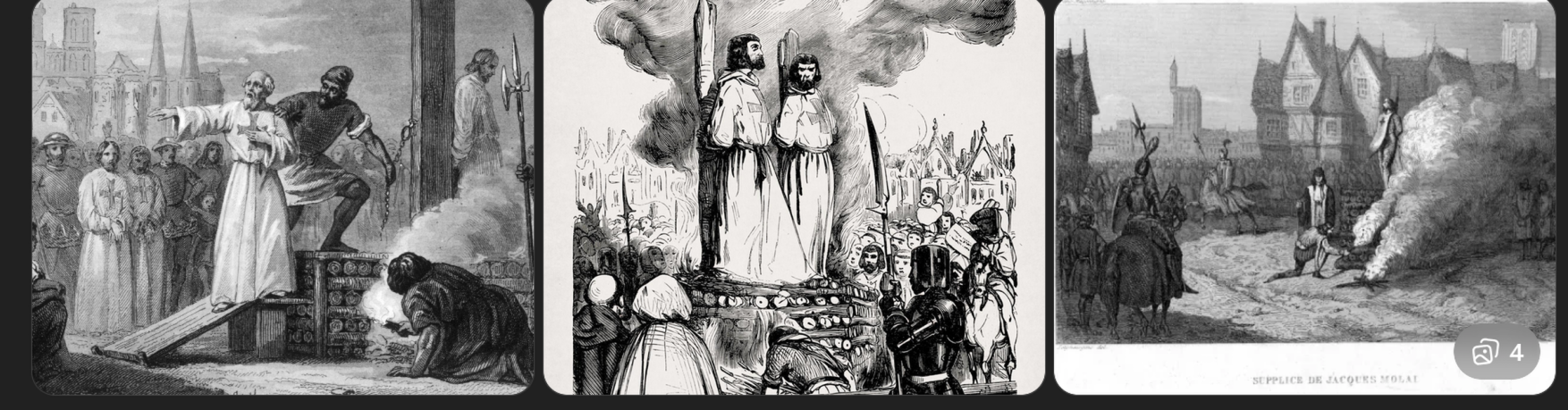
To understand where Templar maritime knowledge might have come from, it helps to understand what actually happened in October 1307 — and more specifically, what did not happen.
On Friday the 13th of that month, King Philip IV of France orchestrated the simultaneous arrest of Knights Templar across his kingdom. The operation was planned with exceptional precision. Philip was heavily indebted to the order and had long resented their independence. The arrests were accompanied by charges of heresy, blasphemy, and ritual transgression — accusations extracted under torture from prisoners who often later recanted.
The suppression of the Knights Templar order was devastating in France, but elsewhere the purge was far less complete. In Portugal for example the order was not destroyed, in fact it positively thrived and was protected by the Portuguese crown. Their, the Templars were reorganised into the Order of Christ, retained their properties, and continued to operate as an institution. Their institutional memory, their accumulated maritime knowledge, and — crucially — the networks of people who held that knowledge, survived intact.
But the most enduring mystery of the 1307 arrests concerns the Templar fleet at La Rochelle. The order maintained a significant number of vessels at this Atlantic port. Records confirm the fleet was present shortly before the arrests were carried out. After the arrests, it was not there. No comprehensive account of its capture or seizure exists in French records. Some of the vessels may have been absorbed quietly into other fleets. Others simply disappear from the historical record.
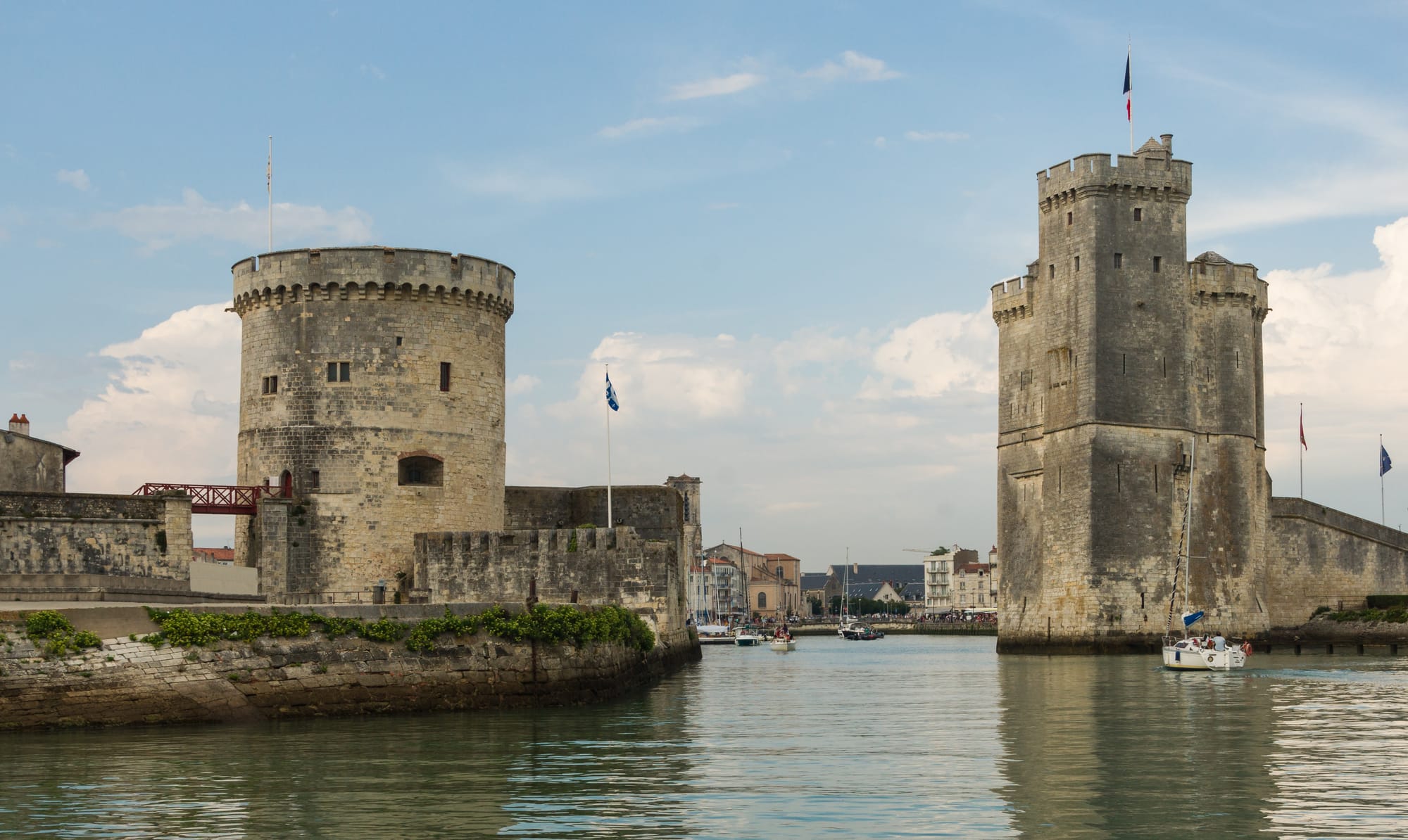
If the order had intelligence — and medieval spy networks were considerably more sophisticated than they are generally given credit for — there was time to act. Assets could be moved. Documents could be transferred. And ships, unlike land or buildings, could simply sail away.
Where did they go? There is no definitive answer. But the Portuguese coast, where the order's continuation was already guaranteed, is the obvious candidate. Scotland is another. Both countries were largely insulated from Philip's reach. Both would become important in later traditions of Templar survival.
The Atlantic Was Already a Known Sea
One of the quiet, important facts about the Columbus story is how thoroughly it relies on the premise that the Atlantic was a barrier rather than a highway. It was not. By 1492, the case that no European had ever reached the American continent was already demonstrably wrong.
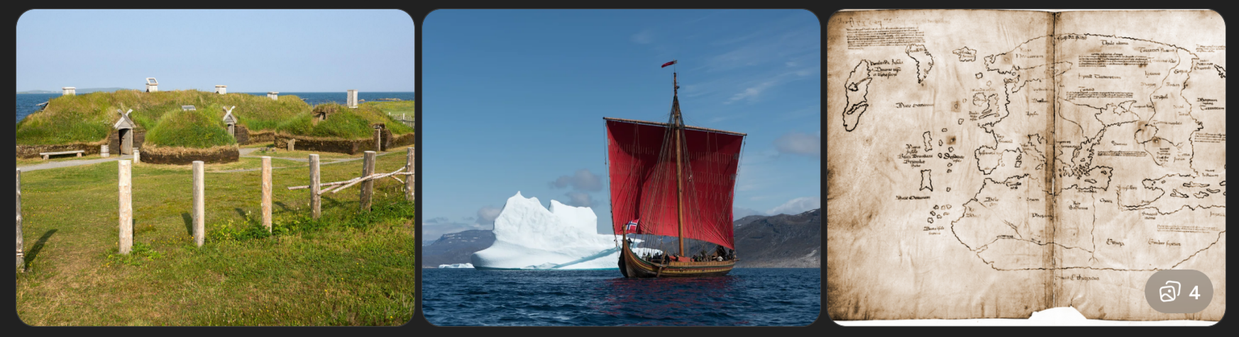
L'Anse aux Meadows in Newfoundland provides the anchor point: a Norse settlement, archaeologically confirmed, dating to around 1000 CE. The Norse had not only crossed the Atlantic; they had settled, explored, argued about whether to stay, and eventually left. Their sagas preserved the memory of Vinland — the fertile land to the west — with enough consistency to suggest the crossings were not a one-off accident but a known route, used repeatedly.
The Norse were not the only ones. Irish monastic tradition preserves accounts of Atlantic voyages going back centuries earlier, and while the most famous, the legend of Brendan the Navigator — blends the mythological and the geographic, it has been taken seriously enough that a modern replica voyage using period-appropriate materials demonstrated the crossing was achievable. Basque fishermen are widely believed to have known of the Grand Banks cod stocks long before Columbus, and to have kept the information commercially guarded.
By the fourteenth century, Portuguese navigators were systematically pushing further into the Atlantic than is reflected in the official record. The Azores, the Canaries, the Cape Verdes — these were way stations in an expanding operational range. Prince Henry the Navigator, whose Atlantic programme was run under the banner of the Order of Christ, was not exploring blindly. He was working from accumulated intelligence, some of it very old, about what lay to the west.
The practical question of whether a Templar-linked network could have reached the American continent is therefore not really a question about whether medieval ships were capable of the crossing. They demonstrably were. The question is whether anyone had the knowledge, the motive, and the organisational structure to attempt it quietly and whether traces of that attempt have survived.
Henry Sinclair and the Voyage That History Cannot Quite Dismiss
Henry Sinclair, Earl of Orkney and Jarl of the Norse territories that gave him access to North Atlantic sea routes, is the figure at the centre of the most detailed surviving account of a pre-Columbian Templar voyage to the Americas. His story has attracted both serious historians and committed debunkers. Neither group has entirely had the better of the argument.
The primary source is the Zeno Narrative, published in Venice in 1558 by a member of the Zeno family, which claimed to reproduce correspondence from the late fourteenth century describing a voyage undertaken by a northern prince. That prince is generally identified as Sinclair, based on the geography described and the presence of Venetian sailors in his service. According to the narrative, the expedition reached a land to the west with abundant forests and a volcanic region, explored it, and returned.
Historians have raised legitimate questions about the Zeno Narrative. The published version was edited and may have been embellished. Certain details are difficult to reconcile. But some of the geographic descriptions — Nova Scotia in particular — align with real places with enough specificity to make the wholesale dismissal of the account uncomfortable. Mainstream history has tended toward scepticism. It has not managed a clean refutation.
What is not disputed is that Sinclair had the means. Orkney's position gave him command of North Atlantic shipping lanes and familiarity with the routes Norse sailors had used for centuries. His family had connections to the Templar order going back generations. The Sinclairs had historically served as the official guardians of the Templar establishment in Scotland. And the voyage date proposed — around 1398 — comes roughly ninety years before Columbus.
If the expedition happened, it would have fed information back into the Templar survivor network operating through Portugal and Scotland. That information could then have moved, through the institutional channels of the Order of Christ, into the charts that sat in Bartolomeu Perestrello's library.

What Did They Leave Behind? The Physical Evidence in North America
This is where the thread becomes most contested and, arguably, most compelling. Because there are things in the ground and in stone across northeastern North America that do not fit neatly into the colonial period timeline, and which continue to generate serious debate among researchers.
Rosslyn Chapel and the Maize Problem
The Rosslyn Chapel built by the Sinclair family in Scotland in the mid-fifteenth century - finished around 1480, well before Columbus sailed contains carvings that have generated a long and unresolved controversy. Among the botanical decorations worked into the stonework, researchers have identified what appear to be representations of maize. Not wheat. Not any European grain. Maize, a crop that was, by every standard account, entirely unknown in Europe until after 1492.
The mainstream explanation is that the carvings represent stylised wheat or some other European plant, and that the resemblance to maize is a case of motivated pattern recognition. That is a reasonable position. The problem is that the resemblance is genuinely close, close enough that botanists who have examined the carvings without knowing the controversy have identified them as maize. If the Sinclair family had access to pre-Columbian knowledge of American flora — through Henry Sinclair's alleged voyage, or through Templar networks these carvings would be exactly the kind of quiet, deniable record that knowledge would leave. Not an announcement. A trace.
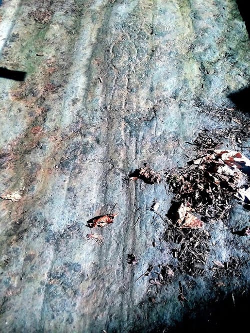
The Newport Tower
Standing in Touro Park in Newport, Rhode Island is a circular stone structure unlike anything else in the colonial built environment of New England. The conventional explanation describes it as a colonial-era windmill, most likely built in the seventeenth century. Several serious architectural analyses have challenged this dating. The structure's proportions, its use of round arches, and its design pattern closely resemble medieval European round churches — specifically the kind associated with the Knights Hospitaller and the Templar tradition of building based on the Church of the Holy Sepulchre in Jerusalem.
Carbon dating of mortar samples has produced ambiguous results that have been interpreted in multiple directions by different researchers. The argument is not settled. What is settled is that the structure is genuinely unusual, and that the colonial windmill explanation leaves aspects of its design unexplained.
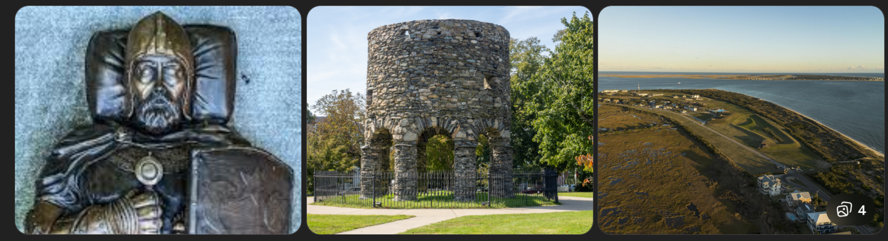
The Westford Knight
In Westford, Massachusetts, a carving on a rock outcrop depicts what appears to be a medieval European knight in armour. Some researchers read the image as showing a figure with a shield bearing heraldic devices consistent with a specific Scottish clan. Others see a naturally weathered rock surface into which too much has been read. The dating is unconfirmed. But Westford sits within the geographic territory that Henry Sinclair's expedition, as described in the Zeno Narrative, would have explored. Its presence in that location, regardless of what it ultimately is, belongs to the pattern.
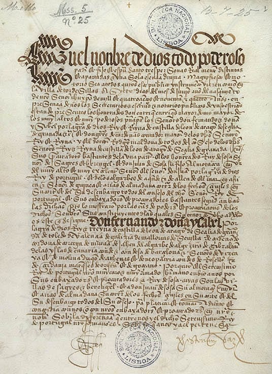
The Kensington Runestone and the Hooked X
Found in 1898 by a Swedish-American farmer near Kensington, Minnesota, the Kensington Runestone is a carved slab bearing a runic inscription that, if authentic, would document a medieval Scandinavian or Templar-linked expedition reaching the North American interior in 1362. The stone has been rejected by mainstream runologists and defended by others with equal vigour. What makes it relevant to this particular thread is not just its age claim but a specific symbol in the carving — the Hooked X, the same mark that appears in Columbus's personal signature. Scott Wolter's forensic analysis of the stone found that the weathering of the carved letters was inconsistent with a nineteenth-century forgery. The debate is ongoing. The symbol connecting it to Columbus is not in dispute.
The Maps That Shouldn't Exist
Perhaps the most intellectually uncomfortable piece of evidence in this entire discussion is not carved in stone but drawn on paper. Several maps produced in the early sixteenth century display knowledge of American geography that the official timeline of discovery does not fully account for.
The Piri Reis map, compiled by the Ottoman admiral Piri Reis in 1513 and discovered in Istanbul in 1929, shows portions of the South American coastline with accuracy that startled cartographic historians when it was first examined seriously. Piri Reis himself stated in marginal notes that he had compiled the map from a collection of earlier source charts — some of them, he indicated, of great age. The accuracy of the South American coastal outline has been argued about extensively. What is not disputed is that the map incorporates source material that predates Columbus's voyages, and that some of that material appears to have been genuine Atlantic cartography.

The Cantino Planisphere of 1502 similarly displays detailed Atlantic coastlines with a confidence that suggests its makers were working from pre-existing knowledge rather than synthesising fresh reports. Portugal's cartographic establishment was, by any measure, the most sophisticated in Europe, and was operating under conditions of deliberate official secrecy. The crown actively suppressed the publication of accurate Atlantic charts to protect its navigational advantages.
If earlier voyages had occurred — Norse, Templar-linked, or otherwise — the knowledge they generated would not have appeared in public maps. It would have been absorbed into the protected archives of institutions like the Order of Christ and transmitted through channels like Perestrello's library. It would show up, eventually, as unexplained accuracy in maps whose sources their makers were reluctant to name.
What Columbus Knew, and What He Chose Not to Say
There is one further detail that tends to be mentioned and then dropped in the mainstream Columbus biography. On a voyage to Ireland in 1477, Columbus sailed to Galway. There, by his own account, he observed two bodies drifting ashore in small boats, described as having unusual physical features. A stone monument on the Galway waterfront commemorates this visit, noting that Columbus found there what he described as signs of land beyond the Atlantic.
On that same voyage, he may have gone further north. Some accounts place him in Iceland, where the Norse tradition of Vinland was not obscure or legendary but a functioning piece of geographical knowledge. The Norse Greenland colony, which maintained intermittent contact with the American continent, had a Vatican representative. Portugal, as a major European Catholic power with excellent Vatican relations, was well positioned to have absorbed that knowledge through official channels.
There is also the question of what happened when Columbus first approached Portugal's King John II with his proposal to sail west. The king consulted his experts. They rejected the proposal but then, covertly, sent a ship to test the theory. The ship returned without finding land. This is documented. It implies that John II believed Columbus might be onto something real, but wanted to verify independently before committing. It also implies the king was not entirely surprised by the proposal. A monarch who already knew western land existed, through channels he was not prepared to disclose, would have had every reason to test a navigator's claimed route rather than simply commission an expedition of his own.
Columbus, turned down by Portugal, eventually took his case to Spain. He was funded. He sailed. He found land where, one might argue, he rather expected to find it.
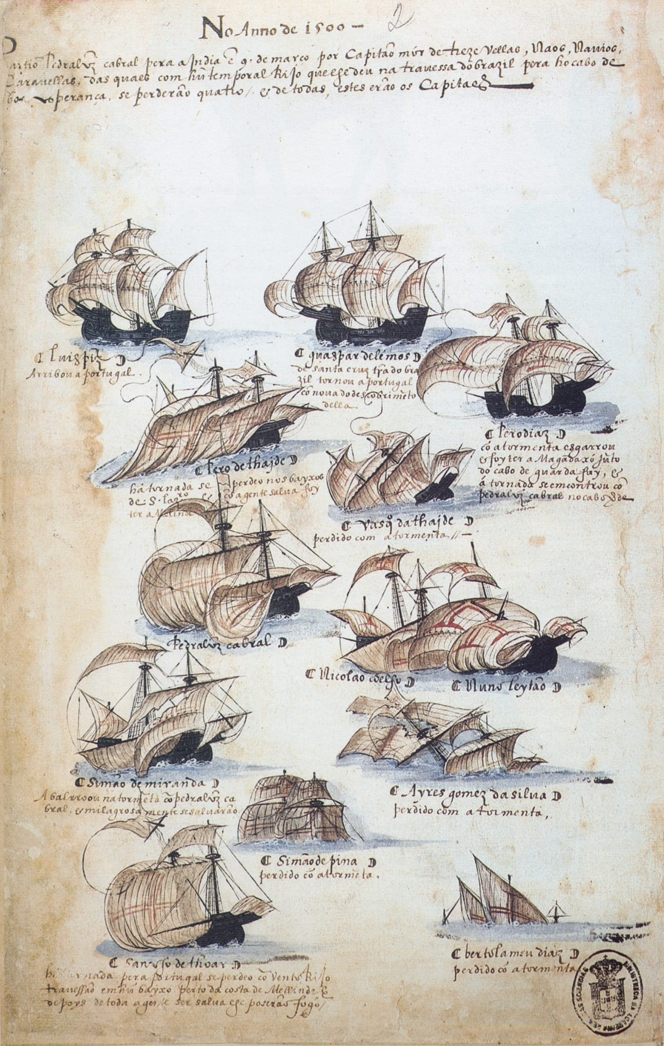
The Treaty of Tordesillas, signed in 1494 between Spain and Portugal following Columbus's return, contains a detail worth noting. Portugal's negotiators insisted on the dividing line between Spanish and Portuguese spheres being drawn significantly further west than Spain had proposed. They eventually got what they asked for — a line that, it turned out, would include eastern Brazil, which Portuguese navigators reached in 1500. How Portugal knew to push for that western boundary, before any official expedition had charted the South American coast, is a question that conventional history tends to move past with some speed.
The Thread That Will Not Close
There is no document that reads: the Knights Templar reached America before Columbus. No confirmed artefact places a medieval French or Scottish monk beyond dispute on American soil. The trail is made of gaps, coincidences, and things that should perhaps be impossible but are difficult to explain away.
What we do have is this. An order with extraordinary maritime resources and an active Atlantic-facing fleet disappeared suddenly in 1307, with its assets unaccounted for and its Portuguese branch intact. That Portuguese branch, operating under a new name but continuous institutional identity, drove the most ambitious maritime programme in European history and became the patron institution under whose cross Columbus sailed. Columbus married directly into that institution's senior cartographic family and spent years with access to its most sensitive archival material. Physical traces in northeastern North America contested, debated, unconfirmed cluster around the geographic area described by the one surviving narrative of a pre-Columbian voyage by a Templar-connected northern nobleman. And the maps produced in the immediate aftermath of Columbus's voyages display a confidence and accuracy that suggests their makers were drawing on something older than 1492.
Individually, each of these elements carries an asterisk. Collectively, they describe a world in which the Atlantic was already known — at least in outline, at least to certain people — and in which the official story of discovery is less a beginning than a publication.
Whether Columbus was a Templar initiate carrying secret charts, or simply a very well-connected navigator who happened to marry into a family that had access to the right information, may be a distinction without much practical difference. Either way, the voyage of 1492 begins to look less like a leap into the unknown and more like a confirmation of something already suspected.
The more interesting question — and this is where the thread leads next is what else was already known. If pre-Columbian contact with the Americas was taking place through Templar and Templar-successor networks, they were not the only ones. The Norse were there. Traditions from multiple indigenous American cultures preserve accounts of contact with light-skinned visitors arriving from the sea. There are the Phoenician hypotheses. There is the question of the peopling of the Americas itself, and whether the story of human arrival on this continent is as settled as it appears in textbooks.
The official story of the Americas before Columbus is a door that, once you start pulling at it, opens onto a much larger and stranger room.
That room is where we are going next.
Related threads: Henry Sinclair and the Zeno Narrative | The Kensington Runestone and the Hooked X | Pre-Columbian Contact: A Field Guide to the Evidence | Oak Island: What Is Actually Down There